![]()

Where in the world...
Houses in Kadzinuni are traditionally built, using local timber for frames, with mud walls and Coco Palm fronds for roofing. Coconuts are the main cash crop grown in the village, mostly sold on after drying out for the extraction of oil which is then exported from Mombasa. To outsiders this at first appears an idyllic location, but whilst the climate is good, with sufficient rain most of the time, there is very little wealth and few people have regular paid work. In some cases a single family member, working away at Mombasa, perhaps in the tourist resorts, will be supporting a large extended family group. Despite this lack of money, the people take pride in the cleanliness of their homes although the lack of modern health care is a major problem. |
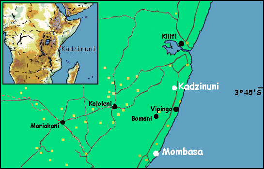
Coastal Province, KenyaKadzinuni Primary School is located just a few kilometres north of the small
town of Vipingo, about one hour's drive from Mombasa, the busiest port of East
Africa. The village is located on a low ridge, only about two kilometres from
the silver white sandy beaches of the India Ocean. The village is set on the
edge of a massive Sisal plantation, which provides some of the local people
with casual work throughout the year. SisalSisal is an important cordage fibre obtained from the leaves of the sisal hemp
plant, an extensively cultivated tropical agave. It is considered second to
Manila hemp in strength and value and is used chiefly for cordage. About half
the sisal produced is exported to the United States and Canada, where much of
it is used as binding twine for grain-harvesting machines.
|
|
Content © 2024 - Nic & Daisy Seller Page last updated 03 Jan 2013 by Dave |
|